|
|
ChartTiff's Next Generation of Topographic Maps are generated from USGS GeoPDFs

O40105c2 (Carter Lake, CO)
ChartTiff NextGen Collarless / Seamless Geo
ChartTiff's Current NextGen's are generated from the latest
Digitally Generated USGS
GeoPDF Topographic Maps.
ChartTiff offers all Historical GeoPDFs
(since 2009 inception) Digitally Generated USGS
Topographic Maps as GeoTiff / JPEG NextGen's
NextGen Geo's are Collarless / Seamless Topographic Maps
No Setting Clipping or Setting a Transparency Layer required
Plug compatible with your GIS System
NextGen DRG's are Collared Topographic Maps
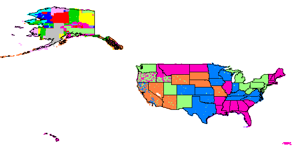
Complete coverage of the US, Alaska, Hawaii, Puerto Rico and Virgin Islands
All States are 1:24,000 Scale Files
Except for Puerto Rico and Virgin Islands that are 1:20,000 Scale
and Alaska that is 1:25,000 Scale
Projection information is selected during Check Out
Select UTM, State Plane, Latitude / Longitude or
Web Mercator
Projection
The projection information applies for complete order
If multiple projections are required please submit multiple orders
Select Output Resolution during Check Out
(600, 500, 400, 300 & 250 DPI Available)
600 DPI Produces largest file size
250 DPI is Compatible with Original Scanned Geos
Optional Layer Selection during Check Out
Select only the layers that you want represented on the map
User will receive:
1 composite map with selected layers
Individual maps with each selected layer
1 composite map with all available layers
Applies to Individual and Custom Area NextGen's
Standard GeoTiff format enhanced with
ChartTiff Extensions
Plus ESRI "tfw" and MapInfo "tab" files
Optional JPEG format -- Selectable at Check-Out
User can add
Shaded Relief
to NextGen Geo's and DRG's during Check Out
User can select ChartTiff
Enhanced Collars
for NextGen DRG's during Check Out
A NextGen Geo or DRG Quad is available as
1 Free Download
ChartTiff NextGen Geos and DRGs are sold by:
|
|
|
|
|
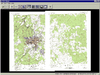
Normal USGS Topographic Maps With Collars
|
ChartTiff Geo's Without Collars
|
-
A ChartTiff Geo map is created from the a USGS DRG topographic maps.
The quad is first projected to your requested projection, then cropped to the map extents.
The voided areas of the map are then filled with the necessary adjacent map information to make the map and Tiff file rectangular.
-
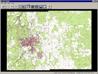
All ChartTiff Geo raster images are geometrically registered at the pixel level from map to map; even from degree to degree.
All ChartTiff Geo raster images allow for easy panning from one map to another, without worrying about map overlap and transparency problems associated with other map products.
-
The Tiff files are then enhanced to the ChartTiff format with additional tags.
ChartTiff is a superset of the GeoTiff standard.
ChartTiff Extensions and Tiff Documentation
|
QUAD Naming Convention
The Quad name format was developed by the USGS and is used to specify the geographic location of a quad map in latitude / longitude coordinates. For example, for quad name O34119d6, the letter "O" specifies the map scale 1:24,000. The number 34 specifies base latitude of 34 degrees, and the number 119 specifies base longitude of 119 degrees.
Each 1:24,000 map location is 7.5 minutes by 7.5 minutes; which equates to 8 x 8 = 64 quad locations in a 1 degree by 1 degree square of geographical area. The 8 rows and 8 columns of quad locations within each square degree are designated by the last 2 letters of the quad name. In this example (O34119d6), the quad is the fourth row (the letter 'd'), and sixth column (the digit '6'). Rows are designated from 'a' (south-most) to 'h' (north-most), and columns are designated from '1' (east-most) to '8' (west-most).
The 64 quad locations for the example are:
| |
Latitude 35 |
|
|
Longitude
120
|
| h8 |
h7 |
h6 |
h5 |
h4 |
h3 |
h2 |
h1 |
| g8 |
g7 |
g6 |
g5 |
g4 |
g3 |
g2 |
g1 |
| f8 |
f7 |
f6 |
f5 |
f4 |
f3 |
f2 |
f1 |
| e8 |
e7 |
e6 |
e5 |
e4 |
e3 |
e2 |
e1 |
| d8 |
d7 |
d6 |
d5 |
d4 |
d3 |
d2 |
d1 |
| c8 |
c7 |
c6 |
c5 |
c4 |
c3 |
c2 |
c1 |
| b8 |
b7 |
c6 |
b5 |
b4 |
b3 |
b2 |
b1 |
| a8 |
a7 |
a6 |
a5 |
a4 |
a3 |
a2 |
a1 |
|
Longitude
119
|
| |
Latitude 34
|
|
|
The following table lists the partial degree
values for the bottom (south) edge
of each quad location:
| |
decimal |
minutes/seconds |
| a |
0.000 |
00' 00" |
| b |
0.125 |
07' 30" |
| c |
0.250 |
15' 00" |
|
d |
0.375 |
22' 30" |
| e |
0.500 |
30' 00" |
| f |
0.625 |
37' 30" |
| g |
0.750 |
45' 00" |
| h |
0.875 |
52' 30" |
|
The following table list the partial degree
values for the right (east) edge
of each quad location:
| |
decimal |
minutes/seconds |
| 1 |
0.000 |
00' 00" |
| 2 |
0.125 |
07' 30" |
| 3 |
0.250 |
15' 00" |
| 4 |
0.375 |
22' 30" |
| 5 |
0.500 |
30' 00" |
|
6 |
0.625 |
37' 30" |
| 7 |
0.750 |
45' 00" |
| 8 |
0.875 |
52' 30" |
|
|
|
MAP SCALES
ChartTiff maps use the USGS file naming convention, in which the first letter of the file name determines the size and scale of the file:
| Letter |
Scale |
Width |
Height |
Comment |
| R |
1:20,000 |
7.5 minutes |
7.5 minutes |
|
| O |
1:24,000 |
7.5 minutes |
7.5 minutes |
|
| P |
1:24,000 |
7.5 minutes |
7.5 minutes |
Orthophoto |
| L |
1:25,000 |
7.5 minutes |
7.5 minutes |
|
| J |
1:30,000 |
7.5 minutes |
7.5 minutes |
|
| K |
1:25,000 |
15 minutes |
7.5 minutes |
|
| I |
1:63,360 |
20,22.5,30,36
minutes |
15 minutes |
Alaska only |
| F |
1:100,000 |
1 degree |
0.5 degree |
|
| C |
1:250,000 |
2 degrees |
1 degree |
|
The remainder of the file name includes the encoded values of
latitude, longitude, and relative location of the map image.
Note: All NextGen 7.5 x 7.5 minute USGS maps are distributed as O files
For a more detailed description of quad name standards, see:
"https://archive.usgs.gov/archive/sites/topomaps.usgs.gov/drg/drg_name.html"
|
|
|